Last Updated on 07/28/2026
The Tug Hill Aquifer is a 47-mile long, 103 mi2 aquifer system that extends from southern Jefferson County, through Oswego County and into Oneida County, and is the source of drinking water for eleven municipalities, as well as the source for private wells serving residences, manufactured home parks, camp-grounds, and other facilities. Water from the aquifer is also used for manufacturing, the dairy processing industry, agriculture, and the NYS Department of Environmental Conservation (NYSDEC) Fish Hatchery in Altmar. Several streams that are hydraulically connected to ground water in the central part of the aquifer are critical fish habitat for salmon and trout, and help support a significant recreational fishing economy.
Critical issues facing the aquifer are impacts from withdrawal and significant development pressure. The northern portion of the aquifer has been designated as a federal Sole Source Aquifer by the US Environmental Protection Agency, where it is the sole or principal source of drinking water for the Hamlet of Adams Center, Hamlet of Pierrepont Manor, Village of Adams, Village of Lacona, Village of Mannsville, and Village of Sandy Creek. Several large changes in withdrawal rates from the aquifer have occurred or have been proposed, including cessation of pumping of a well field for a paper company, purchase of those wells for expanded municipal water systems, a proposed water bottling operation, and declining yields from an aging well field at the state fish hatchery. There are concerns about increased long-term development over the aquifer. Local and state governments, commercial, farming, and individual water users need information to understand what effects these activities may have on the aquifer and how to sustain this resource in support of future growth and economic development.
The Tug Hill Commission is actively seeking funding to pursue mapping of the Southern portion of the Tug Hill Glacial Aquifer.
Tug Hill Aquifer 101 for Local Communities December 2022
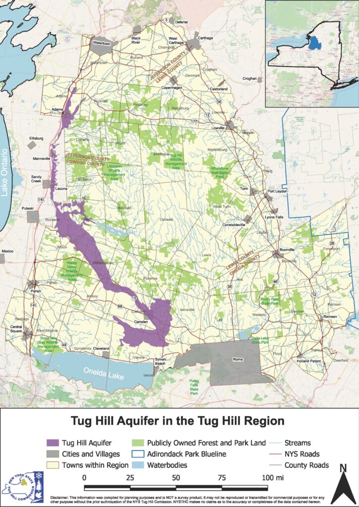
Use the interactive aquifer map below to zoom in on different areas of the aquifer.
Tug Hill Aquifer Resources:
Tug Hill Aquifer 101 for Local Communities (August 2018)
Designation Of Northern Tug Hill Aquifer As Sole Source Aquifer (2007)
May 1, 2014: USGS is looking for homeowners’ wells to measure. View the request letter and maps here: Well_access_letter_Tug-Hill_aquifer_study_041814
The latest update presentation was given by USGS on April 7, 2014. Click Tug Hill Aquifer Progress April 7, 2014 to view the powerpoint.
The previous update was in February 2012. For that presentation, please click this Tug Hill Aquifer Status Meeting, February 28, 2012